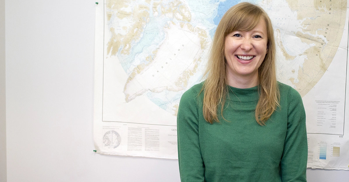
While waiting in line for the Starbucks coffee that she deemed vital for helping her through a long day on campus, Anna Pieńkowski animatedly discussed the ArcticNet-funded project that she and her research team are embarking on. Pieńkowski is a slight, fair-haired woman with a friendly smile and a mysterious accent, which she attributes to her childhood years spent in Poland, Austria and Britain. She is a professor from MacEwan University’s department of physical sciences, and her enthusiasm for her work was obvious when she sat down with the griff to discuss her upcoming research in Arctic Canada, where she and an international team of researchers will work to map the seafloor and uncover the environmental history of the area.
Tell me a little bit about this research project.
The main theme is to map the seafloor. When we do any kind of research on the ship, as we traverse, we can actually map the seafloor. There’s equipment that can show you what the seafloor looks like and what the hazards are. A few years ago, there was actually a cruise ship that ran aground, so there are a lot of hazards associated with that. If you have less sea ice, you’re going to have more shipping, so the rationale for mapping this is to actually be able to produce maps that are reliable, and not have ships run aground. If you think about, say, oil tankers, they’ll have a big environmental impact if they spill oil or something like that, so it’s quite important to be able to navigate safely through waters like that.
What was the inspiration for the project?
The inspiration for the main theme was shipping and navigation safety, but from our side, we are doing more of the environmental stroke or geological side. What we want to know is, as we go through time — as you go from, say, the height of the last ice age, which was about 20,000 years ago — how did this area change? At the very height of the ice age, you have all these huge ice masses, so basically there are no channels there. It’s just glacial ice sitting there. Then, it basically melts away, and then you’ve got this establishment of what we know today as the area. So how did that change in terms of temperature, in terms of salinity, in terms of ecology? So, we’re more from the environmental long-term side, I would say.
You received $492,000 in funding, correct?
The whole project received that, yes. We have not personally received that.
Wouldn’t that be nice, hey?
It would be lovely. It would be fantastic. We would be walking around with tiaras [laughs]. But no, we are just one part. Most of the money that you see goes to the mapping because that’s the most ship-intensive. Typically with a project like that, you get the money and then you can buy ship time. So I think the ship for a day costs something like tens of thousands of dollars — your money is soon spent. So we get a part of that each year for research, for support to get to the ship, but also for supporting students.
Are there students who work on the project alongside you?
Yes. In each of the partner institutions, there are PhDs and Masters and so on. Here at MacEwan, we can only have undergraduates, really, but once we get materials, once we get fieldwork going, there will be projects that students will be working on.
Your research partner, Mark Furze, is also your husband. How has working with your partner (in two ways) been?
It’s fun. We wouldn’t be doing it if it wasn’t. You know, it’s inspirational if you can work and achieve stuff alongside each other. The challenge is that sometimes it kind of takes over your life, so it’s not a 9 to 5 job. It’s kind of always on. But yeah, we enjoy it for sure.
What are both of your roles in the project? Are you involved with the mapping?
We’re not directly involved with the mapping. We are involved in actually retrieving and studying samples from the seafloor — what we call ‘sediment cores.’
The way you can imagine it is basically sticking a plastic tube into the seabed, and then sampling that layer cake of muds and sands and so on. Basically, by doing that, the top [layer] is today. Going back through these layers, you can actually go back in time and study them systematically for a variety of things, from the actual sediment properties to looking at biology or chemistry. So, any fossils or any chemicals that are preserved in there can tell you a lot about what the community of organisms was like — whether it was open water, whether it was sea ice, that kind of thing. These samples are typically anywhere from two to three or four meters long, so you go through the layer cake and sit a lot at the microscope and you build it all together.
What are you hoping to learn or take from this project?
Mostly it is the mapping. It’s that kind of contribution to being able to provide maps that show you where you can actually take a ship. But from our side, it’s more the detailed environmental history — so, really zooming in on what happened with the environment over that long period of time. We’re hoping to get a good grip on establishing when the modern-day oceanography was established in that time. Also, how [do] areas like that respond to climate change? By studying the long-term environmental history, we can actually put a long-term context to it. [pullquote]If you think about it, what we have in terms of climate changing in the last few decades, that’s really a blip in geological history.[/pullquote] We can put a long-term context to it, but also because parts of the time that we study have actually been quite warm in the Arctic, we can see whether there are some parallels. So for instance, how do organisms respond to a warming of the water or to getting rid of sea ice? What kind of different communities of mostly plants, but also animals, would you expect in that area? So you can see parallels of how that kind of region would respond to further warming and the loss of sea ice.
What stage is your team at with the research right now?
The very beginning. We received the funding just before the summer — I think in May. It’s in stages. I think this year, there are people going up on the icebreaker, the Amundsen, and starting the mapping. But yeah, we are right at the beginning, so we are kind of just prepping up.
When are you and Mark going to get up there for the first time?
For this project, I guess probably next year, but it’s kind of up in the air.
What aspect of the whole project are you most excited about?
Oh, the samples, the cores. Totally. We’ve been working on some of these themes for a while, and when you start working on an area, you end up with more questions than you started with. The samples we are taking, we’re hoping [they] will get us closer to sussing out what happened. It’s a bit like a crime scene, you know: reconstructing what happened and how all these different pieces fit in.
Is there anything else you want to add?
I’m excited. I think it’s great that ArcticNet is a consortium of universities and MacEwan has been invited as part of that. So I think it’s quite a nice feather in MacEwan’s cap. And personally, I’m very happy that, one, we got funding, because it’s always nice to have that, but also to be able to take it a bit further and include students in it. It’s always nice to include students in research, so they can actually see what we’re doing, and that it’s not that glamorous [laughs].
This interview has been edited for length and clarity.